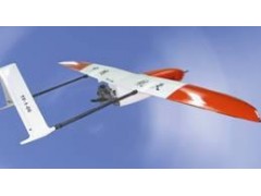


无人机遥感测绘系统可实现遥控飞行和自控飞行,续航时间长,机动性能好,抗风能力强,为资源调查,环境监测提供有力的手段,被广泛应用于土地利用动态监测,矿产资源勘探,地质环境和火灾勘察、地籍测量、地图更新等领域。
The UAV has two fly patterns as remote fly and automatic fly. It features long duration, good maneuverability and strong wind resistance, which can be very helpful for resources investigation and environment monitoring. The system is widely applied in the areas such as land use monitoring, minerals exploration, geology environment and fire survey, cadastral measurement, map updating, etc.